
By Troy M. Ainsworth, Ph.D.
City of Las Cruces Historic Preservation Specialist
In the 16th century, Spaniards crossed portions of present-day New Mexico for the first time. In the case of Alvar Núñez Cabeza de Vaca and his three fellow shipwrecked companions, Estevánico, Andrés Dorantes and Alonso del Castillo 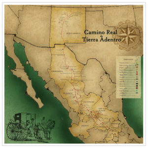 Maldonado, the exact route of these survivors from the Texas coast westward to the Rio Grande, possibly through the Mesilla Valley, and out to the far northwestern frontier of Nueva España remains a matter of conjecture. In sharp contrast, the historical records of the entradas of Francisco Vásquez de Coronado in 1540-1542 and Juan de Oñate in 1598 provide many details about the inhabitants, flora and fauna, and landscape of New Mexico as seen by these early wayfarers. While the eyes of these servants of the Spanish Crown were seeing land previously unbeknownst to their countrymen, their feet were retracing trails and paths that native peoples had walked for at least several centuries.
Maldonado, the exact route of these survivors from the Texas coast westward to the Rio Grande, possibly through the Mesilla Valley, and out to the far northwestern frontier of Nueva España remains a matter of conjecture. In sharp contrast, the historical records of the entradas of Francisco Vásquez de Coronado in 1540-1542 and Juan de Oñate in 1598 provide many details about the inhabitants, flora and fauna, and landscape of New Mexico as seen by these early wayfarers. While the eyes of these servants of the Spanish Crown were seeing land previously unbeknownst to their countrymen, their feet were retracing trails and paths that native peoples had walked for at least several centuries.Along the banks of the great river encountered by Cabeza de Vaca, Coronado, and Oñate, ultimately to be named Rio Grande, stood the settlements and irrigated fields of the region’s early inhabitants. Over the centuries, native populations learned the arts of basket weaving and pottery making, practical 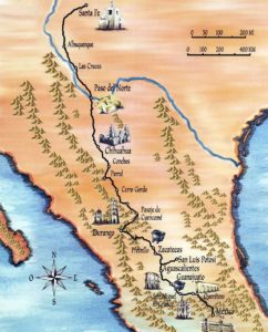 and artistic items worthy of trade with inhabitants residing in the far-flung expanse stretching between the Gulf of Mexico and the Pacific coast. Often, the rivers and streams served as the routes native peoples walked countless miles to trade goods with their neighbors or to hunt migratory game. In essence, their trade routes became the trails crossed by Anglo-Europeans in the 16th century to the end of the 19th century, and many of those routes crossed New Mexico.
and artistic items worthy of trade with inhabitants residing in the far-flung expanse stretching between the Gulf of Mexico and the Pacific coast. Often, the rivers and streams served as the routes native peoples walked countless miles to trade goods with their neighbors or to hunt migratory game. In essence, their trade routes became the trails crossed by Anglo-Europeans in the 16th century to the end of the 19th century, and many of those routes crossed New Mexico.Fifty years ago, on April 24, 1970, the Governor’s Historic Sites Committee entered nine resources into the New Mexico State Register of Cultural Properties, eight of which were historic routes while the ninth resource was directly associated with one of those entities. Their names recall the state’s colorful history—the Zuñi-Rio Grande Trail, El Camino Real de Tierra Adentro, the Santa Fe Trail, the Raton to Santa Fe Stage Route, the Santa Fe to El Paso Stage Route, the Butterfield Overland Mail Route and Alamo Springs Stage Station, the Pecos River Route, and the Goodnight-Loving Trail. Of note, three of these resources cross though Doña Ana County—the former royal road linking Mexico City to Santa Fe and the stagecoach route that closely approximates it between Santa Fe and El Paso, as well as the short-lived mail route established by John Butterfield in 1858.
 What is the significance to Las Cruces of the Camino Real, the Santa Fe to El Paso Stage Route, and the Butterfield Overland Mail Route? Simply put, heritage tourism and the distinction of place. The Mesilla Valley is uniquely situated on the crossroads of North American historical epochs. From the prehistoric era when time and events were memorialized throughout the Chihuahuan Desert in the form of petroglyphs and pictographs through the many subsequent layers of the protohistoric age when accounts were written and published, people have journeyed through and settled in the valley. Waterman Lily Ormsby, Jr. (1834-1908), the first overland passenger over the Butterfield route, passed through southern New Mexico in the final days of September 1858 en route to San Francisco, California. Writing for the New York Herald, Ormsby provided the newspaper’s readers a sense of the land’s character. Upon departing the hamlet of Franklin, Texas, opposite El Paso del Norte, Ormsby wrote, “About twenty-one miles from Franklin we changed horses at a station in a pretty grove of cottonwood trees—the only habitation before reaching Fort Fillmore, eighteen miles further on. This fort consists of half a dozen adobe buildings.… Six miles further on [north of Fort Fillmore] we came to [Mesilla]—but not the [Mesilla] which I had pictured in my imagination as the thrifty town of a fertile valley. True, the fields were groaning with the weight of heavy crops, the dykes or irrigating canals were abundant, and the soil had every appearance of being capable of producing anything that the wants of man might desire or his labors bring forth.”
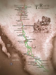
Nearly a century earlier, in March 1750, the Reverend Father Provincial of the Province of El Santo Evangelio reported to the Viceroy in Mexico City on the conditions in New Mexico. Upon traveling along the Camino Real from the metropolis to the far northern frontier, the religious was impressed with the productivity of the missions at El Paso del Norte. “The revenue produced by the mission of El Paso in the year ’48,” he wrote, “exceeded four thousand pesos … and likewise, from the vineyards of the convents of the four missions sufficient grape juice is taken to make more than enough wine for gifts to the ministers and for the sacrament of the masses.” Two distinct observers from very different backgrounds who observed the upper and lower Mesilla Valley at very different times drew similar conclusions about the land’s agricultural potential. From those days to this one, the unique character of the Mesilla Valley continues to entice visitors to Doña Ana County, the borderlands, and, of course, Las Cruces. Those resources designated in April 1970 are assets and useful components to local heritage tourism efforts, and we would be wise to incorporate them into promoting our region’s rich history and culture.